I finally did it! I attended my first photography workshop with Tim Ernst. Tim has been teaching workshops for years. He lives in a cabin (Cloudland) on Cave Mountain Rd. near Boxley Arkansas. On his property he has recently built the Buffalo River Gallery to display his work. This gallery is open by appointment only but it is also where he teaches the processing part of his workshops.
There were six students (counting me) in Saturday's class. We met at 6 am in Ponca. I left home at 2:00 am to get there. Tim gathered us around his vehicle while he went over some preliminary information then we set off for Steel Creek to shoot Roark Bluff. Each of us did our own thing, moving from spot to spot and shooting away. Tim would come by and check on each of us at different times and offer advice and recommendations. We shot until the sun burned through the fog which was close to 9:30. Then, we all followed Tim in a convoy for a 30 minute drive to Cloudland. The last 7 1/2 miles of the drive is on a dirt road. The first mile or so is very steep uphill and curvy. The last mile or so is very bumpy and rough. Despite that it was well worth the drive. Tim's cabin is on the edge of a bluff overlooking the wilderness and the Buffalo River far below.
Whe we arrived, he took us on a tour of the cabin and we met his wife Pam. Pam is a very important part of the workshop. She cooks the lunch. Today's menu was barbeque beef, pork and chicken, barbeque beans, potato salad, chips and drink. Not only did she prepare the lunch but she also baked fresh piping hot chocolate cookies for an afternoon snack. We actually started the processing part of the worksop before lunch but it wasn't long before her voice proclaimed on the telecom system that lunch was ready. We all scurried from the Gallery building back up to the cabin and ate our lunch out on the deck. After lunch we went back to work and actually did not finish until 6:00. My classmates were from Houston Texas, Iowa, Pea Ridge Arkansas, Springdale Arkansas, and Pocola Oklahoma. I learned a lot in this class. It was worth EVERY penny I paid to take it. In fact, I am signing up for a two day workshop that he is teaching next spring. I HIGHLY recommend his workshop to anyone that is serious about photography and wants to improve the quality of the images they take and the quality of the prints that are made. Tim's website is
http://www.cloudland.net/. His site is also a link on my blog.
The following are just a few of the photos from the workshop.
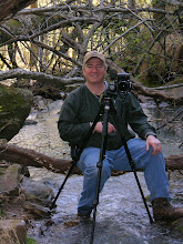
Tim Ernst


 This is not the best picture in the world but the subject is interesting. This is a Champion Tree and the largest Cypress tree in the state of Arkansas. It is also the largest tree in 40 of the 50 states in America. This tree is located in the White River National Wildlife Refuge in East Arkansas. It measures 120' tall with a circumference of 43 feet. A Champion Tree is the largest tree of a species in the state. The Arkansas Forestry Commission keeps a list of our Champion Trees. This list shows the species, the size and where the tree is located. There is even a link to the national champion tree list.